

Once upon a time, I was a Geography major. I’m not anymore, but that’s more of a technicality—I still get to be on the Geography department bowling team. Anyway, part of what hooked me in to geography was that we got to draw maps. I’ve always loved maps. There was a wood puzzle of the United States at the local library that I did over and over again as a child, and the first time I was allowed to go to New York City by myself, I created an elaborate map of all the places my friends and I would go so we wouldn’t get lost. Maps help you figure out where you are and where you’re going, and they tell you where you are and what’s around you. You can buy maps, you can draw maps and you can create them using complicated software.
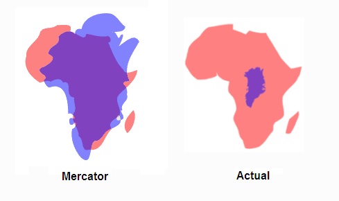
Also, maps are weird because they essentially put a 3-D object (the Earth) into 2-D. This is the rough equivalent of trying to make an orange peel lie completely flat. It can’t be done accurately. This means maps are kinda fucked up, because they go ahead and make the Earth flat anyway, stretching things out and crunching things together. The most classic example of how this distorts things is that in many standard world-map Mercator projection situations, Greenland appears to be the same size as Africa, when actually Africa is WAY bigger.
So maps are malleable, which means they are fun to play with! The internet has come up with a lot of great ways to play with maps. Here are some of my favorites:
GeoGuessr
If you’re in for a challenge, try GeoGuessr. It will take you to a random spot in the world via Google Street View, and your task is to guess where you are.
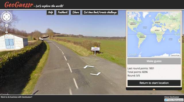
Use the arrows to move along the roads and ascertain more information about where you are. Road signs are really useful for this. You get points based on how close to the actual location you get. Sucks when you think you’re in Texas but turns out it’s really Australia.
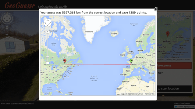
Pro tip: Google Street View has spread quickly (one time I saw a Street View car at mountaintop ruins in Oaxaca, Mexico), but it is not actually everywhere around the world yet, so you are way more likely to get some places than others – hotspots are the US, Canada, Brazil, Australia, and Russia.
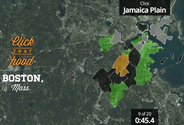
Click That Hood
If you’re more of a Sporcle “pick out the countries and capitals” kind of person, try Click That ‘Hood. It’s a guessing game for different regions and cities. The first time I saw it, I dismissed it as a prettier Sporcle rip-off, but I actually think it’s way better. When you guess wrong, it tells you the right answer and you can try again, and I’ve found that this is actually helping me learn the locations of countries I should have already known.
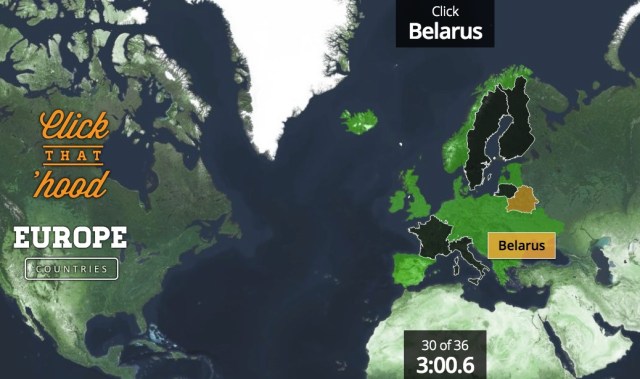
It’s not just countries, either – Click That ‘Hood has games for city neighborhoods all over the world, and a few really random ones where you have to guess different stadiums and airports around the US.
Pro tip: you can use map data to add new places, if you know about that kind of thing (and it even has instructions if you don’t!).
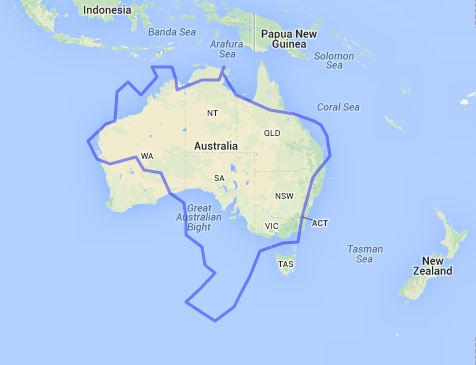
MapFrappe
MapFrappe is not really a game, but a cool investigation in spatial comparisons —”cartographic mixtures,” says site creator Kelvin Thompson. Create an outline anywhere in the world using Google Maps, and then you can move that outline anywhere else in the room to see how they compare, size-wise.
This can easily take up half your day.
Hooked on maps yet? Learn more via the magic of the West Wing:
https://www.youtube.com/watch?v=n8zBC2dvERM
This has been the sixtieth installment of Queer Your Tech with Fun, Autostraddle’s nerdy tech column. Not everything we cover is queer per se, but we talk about customizing this awesome technology you’ve got. Having it our way, expressing our appy selves just like we do with our identities. Here we can talk about anything from app recommendations to choosing a wireless printer to web sites you have to favorite to any other fun shit we can do with technology.
Header by Rory Midhani


Comments
That scene from The West Wing was the first thing I thought of when I saw the title of this post! Love it. Also GeoGuessr is super fun but I never get the answers right.
Me too. I just love that show (and maps) so much.
As a cartographer/GIS technician/former map librarian, this article is amazing. Got the whole office stuck on GeoGuessr a few months ago!
Wow map librarian sounds like my ideal job! But I’m guessing there aren’t too many job openings in that field…
you had me at… ‘Cartographer/GIS Technician’ Ive never heard of anyone else with this title other then people I went to college with… So ‘HI’
I appreciate this post.
Help! I’m addicted to GeoGuessr
I LOVE GeoGuessr.
yay! new ways to be nerdy. :)
I love that video!!! If only we really could get those maps in every public school!
This stuff is elementary compared to the sites you posted, but for folks who are still working on learning their countries, these games are great. http://www.theguardian.com/global-development/interactive/2012/dec/20/geography-game-how-well-know-world
Geoguessr also makes for an excellent drinking/stripping game: you get 2 minutes to guess where you are and if you are within 1,000 km, you make the other person either drink or remove an article of clothing. If you’re more than 1,000 km away, your opponent makes you either drink or strip. Distracting your opponent during the two-minute guess period is encouraged.
Well you just completely revolutionized Saturday nights in my house.
Mind. Blown.
This sounds like pretty much everything I ever wanted in life that I didn’t realize I was missing. Holy crap.
Oh Gods, GeoGuessr! I have lost entire evenings of my life to that game!
This is perfect! I’ve been on a geography kick lately. I started with a Name that Hood addiction – their interface is really smooth and fun to use. But this is the best site I’ve found so far — yes, it’s meant for kids and the look is quite a bit more basic — but it covers more areas and has so many different quiz levels. On one of the more difficult levels, you drag a country shape to where it should be on an unmarked map — easy if the country has a coastline, not so much when it’s landlocked. Slowly working my way around the world, learning what (as you wrote) I should have already known! http://www.sheppardsoftware.com/Geography.htm
(oops – I meant I started with “Click that Hood”)
I love geography games so so so much. GeoGuessr is a lot of fun, another one that I like is http://www.geosense.net/
If I ever get an ipad/tablet, all I will ever do on it is geography/map quizzes
MAPS ARE THE GREATEST
WINKEL-TRIPEL 5EVA
i’m just gonna put this here…
https://www.coursera.org/course/maps
I tried geoguessr last night, it’s really pretty interesting. I was at this one part and I was like this is SO WALKING DEAD right now and guess what? It was right near Fort Benning in Georgia! It’s actually a good game (?) to mess around with. The best is getting put into a different country and trying to identify the language on the signs!
oooh mapfrappe is fun.
i’ve just been dragging Alabama all over the place for 10 minutes.
I LOVE MAPS… HA THATS ALL IVE GOT… most people think its weird…
That clip of the West Wing is one of my very favorites from that show.
“‘Yeah but you can’t do that.’
‘Why not?’
‘Because it’s freaking me out.’”
Also this entire article made me incredibly happy. I didn’t even realize I wanted Autostraddle to have a geography-related column, but I think I’d like to vote for one now.
Do you guys remember the impossible Find the Airport game that tumblr came up with? Anyone? You go to mapcrunch.com, which takes you to a random location via Google Earth street view, and the goal is to find the nearest airport (extreme mode: without using outside help/googling your location).
Have been out of touch with geo games/ apps ever since Geo Challenge (from Playfish) became unavailable from facebook. This is going to bring me back to life. Thanks for these awesome recommendations!