


Right before I moved to New York City, I lived in Austin, Texas, for a couple years. Having grown up in upstate New York, there was a little bit of culture shock, sure, but do you know what actually really bothered me? When I looked outside my window, I didn’t know what the names of the plants were. When Google didn’t turn up any useful information, I used to text photos to my mom (who majored in biology during undergrad) and call her up with lengthy descriptions of all the weeds growing in the sidewalk cracks, to see if we could figure out what these things were called. I pestered my coworkers who grew up in the area, and I visited nature conservatories in search of answers. My mom got me a book, and I eventually figured out what some of the most common plants were. But I still don’t know what to call the majority of Texan flora, which annoys me to this day — particularly when I go back to visit.
All this to say: I am a person who really likes to know what’s going on around me. This is true when I look down at the ground, and it’s also true when I look up at the sky. I just like to know things. And while I haven’t figured out a technological solution to the plant thing yet (suggestions welcome!), it turns out there are a lot of tools out there to figure out what you’re looking at when you cast your eyes upwards.
So if you look out your window and feel a shared sense of nerdy curiosity about the world around us, these apps are for you, friend. I put my three favorites, but if you have more, I’d love to hear about them in the comments.
Spot The Station
Several times a week, Mission Control at NASA’s Johnson Space Center in Houston determines space station sighting opportunities for over 6,700 locations worldwide. A complete list of all possible space station sightings is available at Spot The Station’s location sightings pages, but my favorite thing is that they also give you the option to sign up for text message notifications specific to your area. Depending on the space station’s orbit, you’ll get good viewing opportunities anywhere from once or twice a week to once or twice a month.
The information comes in like this:
SpotTheStation! Time: Wed Apr 25 7:45 PM, Visible: 4 min, Max Height: 66 degrees, Appears: WSW, Disappears NE.
Which matches up to the real world like this:
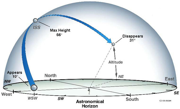
All sightings occur within a few hours before or after sunrise or sunset. This is the optimum viewing period as the sun reflects off the space station and contrasts against the darker sky.
What I really want to do is take a look at the station through a telescope during one of these periods of visibility. It hasn’t happened yet, but maybe later this year!
Check it out: spotthestation.nasa.gov
Sky Objects
In a similar vein of geekery, Sky Objects is a augmented reality phone app. It allows you to point your phone at the real actual sky and see a map of information about what you’re looking at. (Note: if you were an early Android adopter, you probably got Google Sky Map pre-installed on your phone several years ago. Sky Objects is similar, but it goes one step further by also including human made objects.)
This is what the map looks like:
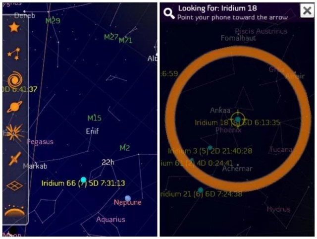
Constellations are outlined and named, along with stars, Iridium Flares, and satellites (although those are kind of hit-or-miss).
This app is super fun to play with, and I also find it useful for settling debates with my girlfriend about whether we’re looking at a star, planet or plane. (I don’t know why this always comes up, but it definitely does!)
Check it out: Android
Flight Radar 24
This app isn’t augmented reality, but it’s still pretty cool. What it does is take radar data from planes and plot their locations on a map. There’s some lag (it takes time to process all that data!), but the end result is that you can look at any plane in the sky, pull up this app, and identify the plane’s flight number. Plug that into Google, and now you know what type of plane it is, where it’s from, and where it’s going.
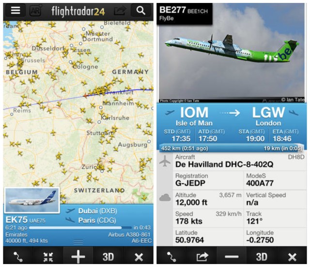
I use the free version, but if you get the paid version you can skip the Google step; it pulls that info for you, along with some other stuff like altitude, speed, latitude and longitude.
Check it out: website / Android / iPhone (Regular is free, Pro is $2.99)
This has been the one-hundred-second installment of Queer Your Tech with Fun, Autostraddle’s nerdy tech column. Not everything we cover is queer per se, but we talk about customizing this awesome technology you’ve got. Having it our way, expressing our appy selves just like we do with our identities. Here we can talk about anything from app recommendations to choosing a wireless printer to web sites you have to favorite to any other fun shit we can do with technology. Feature image via XXXX. Header by Rory Midhani.


Comments
Oh my god! Queers and flying! Two of my favourite things! Together! On Autostraddle!!!
Today is the day to REJOICE!!! :))))
Thank you for this article, Laura. Like feminist movement conversations and posting pictures of cute kitties, tech is a domain queers should own too! Geeky lesbos unite.
<3
I just got a job next to Sydney Airport, so if I got that flight app it would severely limit my productivity…
YES! Just signed up for SpotTheStation texts! I may not have much of a social life, but at least NASA loves me. (And thank you for the helpful diagram.)
Also cool – google sky (https://www.google.com/sky/)
My partners and I went to the planetarium last weekend so these apps are very relevant and awesome. Thank you!
The plant thing also drives me crazy! I really want there to be an app where I can take a picture of a plant on my phone and then it will, like, magically search a database or something (maybe based on your location?) and give you suggestions. If anyone invents such a thing, I want to know! :-D
iNaturalist – not only can you get help with id’s, but you might be helping out scientists with your observations as well – getting and giving!
oh, and this goes for plants, animals, insects… just about anything alive in nature…
Ahhhh thank you!! That’s amazing, can’t wait to try it!
ooooooooh
I’m definitely going to try this one. Thank you!
i just signed up myself – my inaturalist user name is “greybex” – look me up! it’d be so cool to have a circle of interwebnet ‘straddler-naturalists!
Ooh, fun! I signed up too, username girafferiffic. It’s getting to the time of year here where everything is dying off/checking out for the winter, but I know I’m going to use the heck out of this thing come spring – my house borders on a small wooded area and there were so many Mystery Plants back there this year!
Leafsnap! For tree ID in the northeast